Evolution, settlement plans and architectural highlights
 Distribution map of Mature Harappan sites Distribution map of Mature Harappan sites |
Kunal, Dholavira (Kotda), Banawali, Kalibangan, Surkotada, and Lothal are settlements unearthed between 1955 and 1995. These sites provide the links between the Early Harappan and Mature Harappan phases of the civilization. Mature Harappan phase is closely associated with the use of weights and measures, seals and sealings and a system of writing, all facets associated with trade and commerce. Sealings were used to seal traded packages. ca. 2600 BC when the Mature Harappan phase blossomed there was evidence of trade with several sites in Western Asia (Tell Asmar, Tell Agrab, Kish, Nippur, Ur, Susa, Failaka, Tell Abraq, Umm An-Nar, Hili, Ras Al-Junayz, Tepe Yahya, Shahdad, Sutkagen Dor) and some sites in Central Asia (Shortughai, Namazga-depe, Altyn-depe, Tepe Hissar).
All these six settlements are on the banks of rivers/tributaries along the course of the Sarasvati river. In these Early Harappan sites, there is evidence of town-planning (i.e. laying-out of streets and houses along cardinal directions), fortification of settlements and the concept of dividing the settlement into two parts: the citadel and the Lower Town. These characteristics anticipate the Mature Harappan characteristics. In Banawali, there is evidence of the use of fired-bricks even during the Early Harappan phase. It should, however, be noted that many houses at Banawali, Kalibangan and Lothal were made of sun-dried bricks.
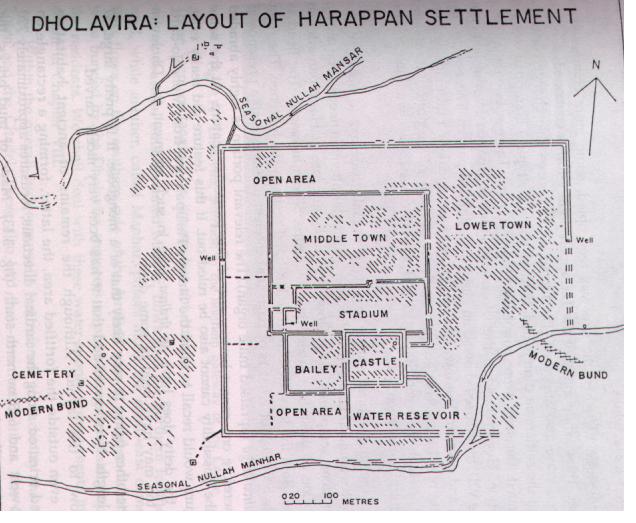 Dholavira (Kotda) (After Bisht 1989) Dholavira (Kotda) (After Bisht 1989) |
 Banawali (After Bisht 1994) Banawali (After Bisht 1994) |
 Kalibangan (After Lal, 1998) Kalibangan (After Lal, 1998) |
 Surkotada (after Joshi 1990) Surkotada (after Joshi 1990) |
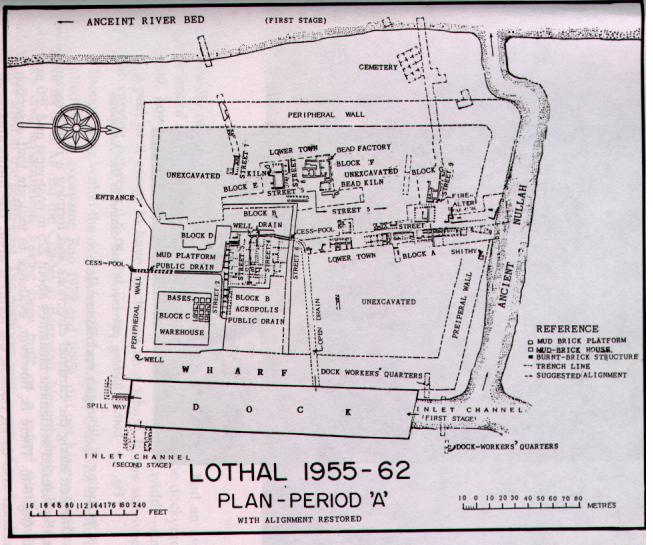 Lothal (After Rao 1979) Lothal (After Rao 1979) |
|
  Kunal: Silver ornaments, spiralled silver bangles |
 Discular beads of silver with axial perforation, Early Harappan, Kunal |
Discular beads of gold with axial perforation, Mature Harappan, Lothal |
 Kunal: early Harappan pottery, peacock and pipal designs |
Kunal. A small area of 1.2 hectares with a vertical deposit of over 3 m. The radiocarbon dates place the site between ca. 3016 and 2577 BC (Lal 1997, p. 84). Copper arrow-heads and fish-hooks; micro-beads of chalcedony. Red ware bearing painted designs in two colours (black outline filled in with white) are characteristic of a number of sites along the Sarasvati_ valley. Potsherds of Hakra ware (Cholistan) were also found at the site. In the next period, painted motifs on pottery included peacock and pipal leaf, typical of the designs of the Mature Harappans. A globular jar of red ware yielded silver ornaments wrapped in a silver sheet: two tiaras (small and large), each with a large fully-opened flower having petals topped with a decoration like the Greek letter 'alpha' (Khatri and Acharya, 1995: 86) Along with these tiaras was a multi-spiralled armlet which is similar to the armlet worn by the bronze statue of the 'dancing girl' from Mohenjodaro. In another house were found a large number of gold/silver-beads: cup-shaped, barrel-shaped, discular; shapes which are characteristic of the Mature Harappans. Discular beads of silver with perforation along the diameter found in Kunal (Hissar, Haryana) have occurred at Mature levels at Lothal, in gold. Other parts of the site yielded beads of lapis lazuli, carnelian, faience. Copper objects were produced at the site as evidenced by the discovery of a terracotta crucible with molten metal still sticking to it. The objects included: axes, fish-hooks, spearheads, iverted 'V-shaped' arrow-heads, coiled cones and coiled finger-rings which are characteristic of Mature Harappans. Seven seals (six of steatite and one of shell) were found. They are square-shaped with a perforated knob at the back, again anticipating the Mature Harappans. The seals bear only geometric motifs and without any inscriptions.
 Dholavira: Terrace in front of northern gateway |
 Dholavira: well in the citadel |
  Dholavira: reservoir, diverting the water from nullah, drawing water from well |
Dholavira (Kotda). On one of the islands of the Rann of Kacch. Fortified settlement, with fortifications separately for the Middle Town and the citadel. The citadel commanded the entire scenario with a height of 15 to 18 m. above the surrounding ground level. Seasonal nullahs (Mansar and Manhar) flow past the northern and southern sides of the fortified area. The nullahs were bunded to supply water to the tanks and wells.
A well has been discovered south of the 13m. wide street in the citadel.A horizontal slab of the trough had markings showing the passage of the rope used to draw water from the wall. Water drawn from the well was conducted through a covered channel to feed a nearby tank (4.35 m X 2.95 m.) with a depthof 3.58 m. Side walls of the tank were formed by vertically placed stone slabs; the upper part had stone-rubble masonry. The floor was paved with stone slabs. Sketch 1 illustrates the damming of the Manhar nullah to divert the water to the reservoir. Sketch 2 illustrates a pair of bullocks drawing water from the well.
 Dholavira: staircase, northern gateway of castle |
 Dholaviara: eastern gateway of castle, ring-stone pillar bases in situ |
 Dholavira: Sign-board inscription |
 Dholavira: stone pillars |
The citadel had two gateways: one on the northern and the other on the eastern side. Each gateway had an elaborate staircase. The landing of the staircase was at a depth of 2.3 m. After ten steps and a further descent of 2 m., the staircase led to a passage way which was 7 m. long On either side of the passage, there was a chamber which had a roof resting on stone pillars. In one of the chambers, a unique inscription was discovered. The ten letters of the inscription had a height of about 35 to 37 cm. and a width of 25 to 27 cm. The letters wee made of sliced pieces of some 'crystalline material, maybe rock, mineral or paste'. Perhaps mounted on a wooden board, the inscription might have constituted a sign-board. Ring-stones were used to support the pillars.
The eastern gateway also had a staircase and passage way with a chamber on either side. Many well-polished stone pillars were found in situ. Similar polished pillars were later found as belonging to the As'okan times, the third century BC.
Banawali. Left bank of the Sarasvati_ river. 20 km. from Kunal. Fired bricks had been used even by the Early Harappans as evidenced at this site. Settlement within a single fortified area. Within this area, the citadel had its own fortification, in a semi-ellipse, with wall-thickness varying from 5.4 to 7 m.
 Kalibangan: 7.2m wide street |
 Kalibangan: a Lower Town street |
Kalibangan. Left bank of the Sarasvati_ river. Citadel on the west; fortified Lower Town in the centre; ritualistic structures on the east. Fortification walls were made mostly of mud bricks, but at a few places kiln-fired bricks were also used. Early brick sizes were 40X20X10 cm. and later ones were 30X15X7.5cm. Street-widths were: 1.8 m., 3.6m, 5.4m and 7.2 m. (note the ratio of 1:2:3:4) On the floors, soiling of terracotta nodules intermixed with pieces of charcoal was overlayed with the clay floor. (The practice is followed even today in many villages.) Between 2600 and 1900 BC, Kalibangan witnessed about nine reconstructions, but not a single structure intruded on the street.
 Kalibangan: sealing of clay |
Kalibangan: faulted strata |
Kalibangan: faulted walls |
A sealing of clay. The bottom row shows the impressions of reeds and the knotted thread which were used to tie the package. A lump of clay had been placed over the knot and the clay was stamped with a seal.
A black layer had been ruptured at three places. In between the ruptured parts of the layer are seen near-vertical cleavage lines. These are an indication of some tectonic disturbance. After this shake-up, there was no further occupation at the site and the site was abandoned. This evidence is substantiated in another part of the site showing faulted mud-brick walls. Two successive mud-brick walls are shown sunken and cleft, with a pronounced cleavage in the lower wall. "The most plausible explanation seems to be the occurrence of an earthquake which not only destroyed the houses but also forced the inhabitants to leave the site. This event may have taken place around 2700 BC, since, after a break, the reoccupation of the site by the Mature Harappans is ascribable, on the basis of radiocarbon dates, to ca. 26th century BC." (Lal, opcit., p. 66)
 Kalibangan: row of seven fire-altars |
 Kalibangan: brick-lined pit with bones |
 Kalibangan: terracotta bull |
 Kalibangan: bronze bull |
 Kalibangan: cylinder seal and its impression |
The site yielded a large number of tools and other objects in copper and bronze: axes, bangles, besides a paras'u_, a tool used even today in Rajasthan to cut the shrubs. A row of sevel 'fire-altars' were found in the citadel of Kalibangan. The altars were sunk into the ground, to a depth of about 25 cm. The sides were plastered with mud. A central cylindrical (sometimes faceted) stele of clay (sometimes fired) about 30 to 40 cm. high and 10 to 15 cm. dia. in the altar is a characteristic find in many sites. Around the stele lay circular-biconvex 'cakes' of clay; ash and charcoal were also attested. (Mughal had demonstrated that in Cholistan sites, the 'cakes' were used to support the pottery being burnt.) The altars were so located that the offerer had to sit facing the east. Embedded into the ground next to the sevel altars was a pot which contained ash and charcoal. A well, bathing pavement and a drain were closeby, indicating the use of water to put out the burning embers after the metallurgical processes were completed. Another platform in the southern part of the citadel yielded a pit, measuring 1.5 m X 1 m and lined with kiln-fired bricks. In this pit, bovine bones and bones of antlers were found. It has been recorded that bones are used to in the process of oxidizing and removing lead from galena to yield silver. To the east of the Lower Town on a small mound, only the remains of fire-altars were found.
Surkotada. 160 km. northeast of Bhuj in Rann of Kacch. A common 7m. thick wall with an opening, separated the citadel and the Lower Town. The citadel was built over a platform. The entrance to the citadel was provided with a ramp, barbican, steps and guard rooms. "...was there any special reason for this small yet fortified establishment? Had we enough evidence about the war-equipment of the Harappans, we would have taken Surkotada as a garrison town." (Lal, op cit., p. 37). Four graves were excavated in Surkotada. None of them was the extended burial type evidenced in Lothal. In one grave, 'the pit yielded a red ware sherd of an urn and very small charred human bone splinters or remains... The post-cremation human remains found in a burial bear a great significance. The relatives of the dead in all probability out of regard for the deceased used to take care of the burnt or charred bones after submission of the corpse to fire'. (Joshi, 1990: 369).
 Lothal:
dockyard Lothal:
dockyard |
|
 Lothal: bead-making kiln |
 Lothal: microbeads of gold |
 Lothal: terracotta horse |
Lothal. On the banks of a tributary of the river Bhoga_vo which joined Sa_barmati_ which fell into the Gulf of Khambat (an inlet of the Arabian sea). Fortified settlement. Mud-wall of an average thickness of 12-13 m. On the eastern side, against which the dockyard was located, the wall measured 20-21 m. in width. Part of the wall had served as a wharf. Estuarine shells were found in the complex substantiating the structure as a dockyard. To the west of the wharf was a mud-brick platform (48m X 40 m) called a 'warehouse'. A series of square mud-brick blocks were found on the platform with an intermediary passage of 1.2 m. width. In the passage were found: charred log, plenty of ash and charcoal and 65 burnt sealings of clay, with impressions of the wrapping fiber and knotted thread on one side and of seals on the other. This is evidence that the platforms had held stamped packages.
The citadel or acropolis was built on a raised platform, 3.5m. high. Twelve bath-pavements with accompanying drains. To the south of these structures was a 'warehouse'. Apart from a house which yielded copper ingots, crucibles etc., a bead-making kiln was identified.
Bisht, R.S., 1982, Excavations at Banawali: 1974-77. In G.L. Possehl (ed.) Harappan Civilization: A Contemporary Perspective, p. 113-24. New Delhi: Oxford and IBH Publishing Co.
Bisht, R.S., 1989. A New Model of the Harappan Town Planning as revealed at Dholavira in Kutch: A surface study of its plan and architecture. In B.Chatterji (ed.), History and Archaeology, pp. 397-408. Delhi: Ramanand Vidya Bhavan.
Bisht, R.S. 1991. Dholavira: New Horizons of the Indus Civilization. Puratattva, 20: 71-82.
Bisht, R.S. 1994. Banawali. In J.P. Joshi and R.S. Bisht, India and the Indus Civilization, pp. 23-31. New Delhi.
Joshi, J.P., 1990. Excavation at Surkotada 1971-72 and Exploration in Kutch. New Delhi: Archaeological Survey of India.
Khatri, J.S. and M. Acharya. 1995. Kunal: A New Indus-Saraswati_ Site. Puratattva, 25: 84-86.
Lal, B.B., 1997, The Earliest Civilization of South Asia, New Delhi: Aryan Books International.
Lal. B.B., 1998, India 1947-1997: New Light on the Indus Civilization, pp. 154. New Delhi: Aryan Books International.
Rao,S.R. 1979. Lothal--A Harappan Port Town 1955-62, Vol. I. New Delhi: Archaeological Survey of India.
Rao, S.R. 1985. Lothal--A Harapan Port Town 1955-62. Vol. II. New Delhi: Archaeological Survey of India.
Sali, S.A. 1986. Daimabad 1976-79. New Delhi: Archaeological Survey of India
Sharma, A.K. 1993. The Harappan Horse was buried under the Dune of..., Puratattva, 23: 30-34.
| Advertise with us! |
|
|